Distance: 7.5 mile loop
Finding Beacon Rock State Park is simple. Just head east on HWY 14. When
you see Beacon Rock jutting out of the ground to your right, you’ll approach a
parks information station to your left (~40 miles from downtown Vancouver). To find the trailhead, veer left just
past the information station and follow the road to its end. If you reach Bonneville Dam, you’ve over shot
the park by about a mile.
Hamilton Mountain rivals Beacon Rock as the most popular Columbia Gorge hiking
destinations of the Washington side; and for good reason. Hamilton Mt. is a
relatively short driving distance from town and provides a rewarding payoff-to-effort ratio. You'll view both Mt. Hood and Mt Adams from the summit of Hamilton Mountain.
 |
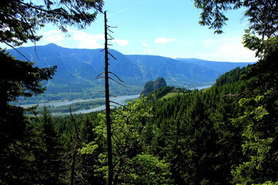
| Panoramic of Cape Horn Viewpoint |
There’s
a great panoramic view of the Columbia Gorge along HWY 14 in route to the trailhead. Keep your eyes
peeled for Cape Horn Viewpoint. The spot approaches quickly and only has room
for a couple cars.
The trail begins with an ascension through a heavily forested
area. Less than a half mile along the way, a power line clearing opens up views of the Columbia River and Bonneville Dam. A community carved bench sits under the power lines facing the river.
 |
| Pool of the Winds |
 |
| Hardy Falls during the Winter |
Continuing
through the forest, your next destination will be Hardy Falls and Pool of the Winds. A short trail junction will take you to the upper portion of Hardy
falls. Not the best water fall view, but hold your breath, Rodney Falls is next.
 |
| View of Beacon Rock |
After
Rodney Falls, follow the wood railed ascent to a brief tree clearing with Beacon Rock in the distance. Continuing through the forest, hikers will
approach a fork in the road. Choose left
for “Hamilton Mt. – difficult trail” of choose right for “Hamilton Mt. – more difficult
trail.” This junction marks the beginning of Hamilton Mt. Loop, which intersects again at the summit. I went right. I chose the shorter yet steeper path. The "more difficult" path exposes hikers to the Gorge, whereas the "difficult" path exposes hikers to inland hills and mountains.
 |
| Panoramic view from Little Hamilton Mt. |
A dozen
switch backs through the forest later, you'll reach Little Hamilton
Mountain. Providing a fantastic panoramic view.
 |
| Hamilton Mt. from Little Hamilton |
In the distance, the true Hamilton Mountain lies. This may seem daunting, but the
mountain is closer than you think. Continue
along the bare, open hillside. There are plenty of good photo opportunities of Bonneville
Damn and the Columbia Gorge.
 |
| Bonneville Dam |
 |
| View from Winter |
Little
Hamilton Mountain, in many ways, is more rewarding than Hamilton Mountain summit. However,
only from the peak of Hamilton Mt. can you see both Mt. Hood and
Mt. Adams.
 |
| View of Mt. Adams |


No comments:
Post a Comment