Friday, October 24, 2014

Devil's Punch Bowl

Distance: <1 mile
I must begin by mentioning that this "hike" doesn't involve a trail. Yes, there may be a distinguished path leading from the parking area, but that path leads to a beach. Once there, you may proceed as you see fit... Or, you may drive straight to the overlooking Devil's Punch Bowl viewpoint, which requires zero hiking.

To find the beach, head south on Hwy 101 from Lincoln City for about 16 miles before taking a right at Otter Crest Loop Road. The road is between the cities of Depo Bay and Newport. From here, take the split left to Devil's Punch Bowl viewpoint. Just follow signs from here. Beach access can be found by taking a right on Sea Crest Dr and following the road to it's end.
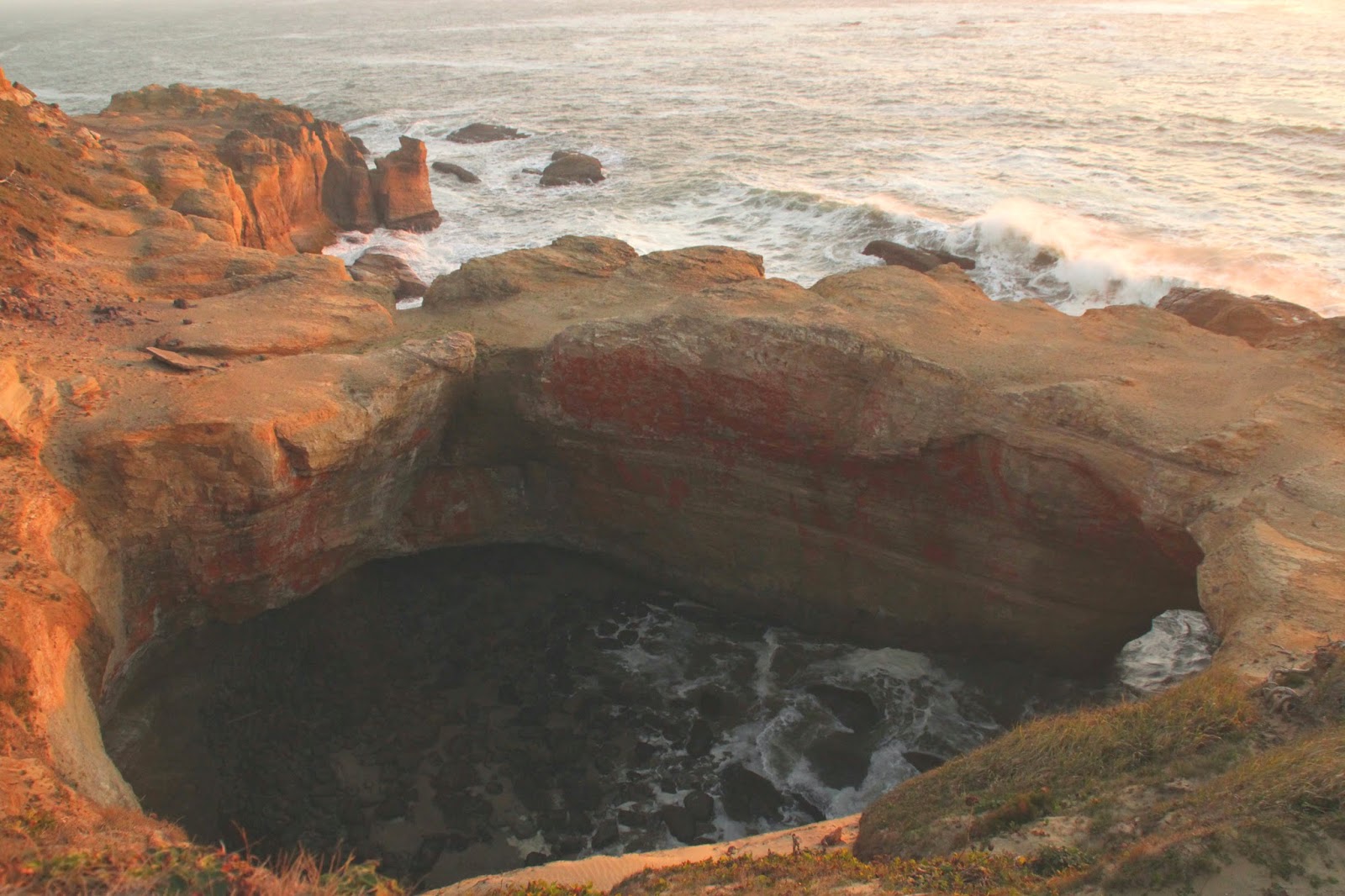
Devil's Punch Bowl from Viewpoint

Wednesday, October 22, 2014

Rattlesnake Ledge

Distance: 4 miles round trip
Rattlesnake Ledge is a very popular destination from the Seattle metropolitan area. Located 34 miles from downtown, it's just far enough to escape the city, but not too far. Just head East on I-90 out of Seattle until you reach the North Bend/Snoqualmie Pass area.  Take exit 32 and follow Cedar Creek Rd south until you reach the parking lot. It's not your typical trailhead parking lot - this one accommodates a high volume of visitors.
Rattlesnake Ledge

Wednesday, September 3, 2014

Jefferson Park

Distance: 11 miles round trip
Jefferson Park is an alpine wonderland for the backpacking enthusiast. There are several lakes, ponds, and meadows scattered around the base of Mt. Jefferson. Consider staying multiple nights to explore, take pictures, fish for trout, or just relax in the beautiful scenery. Seriously an impressive area.

To find the trailhead from Salem, start by taking Hwy 22 east towards Detroit Lake. As soon as you reach the small town of Detroit (~50 miles) take a left onto Hwy 46 and head east. Remain on Hwy 46 until the road takes you North (~15 miles). At this point, take a right on NF-4220. After seven miles of this narrow, rocky road, you will reach the trailhead, AKA the Pacific Crest Trail (PCT). BEWARE: this road is very rocky, consider driving an AWD vehicle with high ground clearance. Also note that NF-4220 and parts of Hwy 46 are closed between Nov-June. 
Mt. Jefferson

Tuesday, August 19, 2014

Moraine Lake

Distance: 4.6 miles out and back
Moraine Lake is a solid backpacking destination only 25 minutes outside of Bend, OR. Just travel  west on Hwy 372 towards Mt. Bachelor. The trailhead is located at Devils Lake, just ten minutes past Bachelor. Bring your NW forest pass or pay the $5 day fee. Because Moraine Lake shares its path with South Sister, the trailhead can be quite crowded in the summer. Hit the road early.
South Sister - Atop the Forest

Monday, August 18, 2014

South Sister

Distance: 11 miles round trip
South Sister is the third highest peak in the state of Oregon. Only Mt. Hood at 11,250’ and Mount Jefferson at 10,495’ are taller than South Sister’s highest point of 10,358’. The trail is very well groomed and doesn't require any bouldering or rock climbing skills. However, that doesn't mean the trail is easy… Long, insanely steep stretches with loose footing, make this trail one of the most taxing day hikes in Oregon.
 

To find the trailhead from Bend, travel west on Hwy 372 towards Mt. Bachelor. The trailhead is located at Devils Lake, just ten minutes past Bachelor. Bring your NW forest pass or pay the $5 day fee, strap on some gaiters, and lube up with sun block. If you have a light weight water filter it could come in handy. Depending on your pace, it could take anywhere from six to ten hours to complete this hike... That’s a lot of water weight to carry. There are a couple very good water sources you can take advantage of.
 

The trail log below details the 5,000 feet of elevation gain and 5.5 mile trek to the summit in five distinct phases: The Forest, Flat Ground!, First Incline, Second Incline, and Summit.
South Sister

Tuesday, August 12, 2014

McCall Point

Distance: 3.6 miles out and back
McCall Point is an easy, yet scenic, Gorge hike that can be enjoyed all year long! However, I would highly recommend the spring – the trail is lined with balsamroot and other wildflowers that die off in the summer heat.

The hike begins at Rowena Crest: a large roundabout viewpoint overlooking the Columbia River. From Portland, you will travel east on I-84 for about an hour before taking exit 69 for Mosier.  Continue east on Hwy 30 for about 20 miles. Follow the signs for Rowena Crest and park on the shoulder of the road
in the gravel. The trailhead is facing north from the roundabout.
Mt Adams, Columbia Gorge, and Rowena Crest

Wednesday, July 2, 2014

Tom, Dick, and Harry Mountain

Distance: 6 miles round trip
The trail to Tom, Dick, and Harry Mountain provides so much bang for the buck! Assuming, of course, you've chosen a clear day. Mt. Adams, Mt. Rainer, Mt. St. Helens, Mt. Jefferson, and, obviously, Mt. Hood are visible from the summit. The six mile jaunt is a perfect day trip from Portland! Pair it with a visit to Mt. Hood Brewery Co. (less than 2 miles from trailhead) or camp for the evening at the family friendly Mirror Lake.

The trailhead is located on Hwy 26 right as you approach Government Camp in Mt. Hood National Forest. From Portland, travel I-84 east and take exit 16 south on NE 238th Dr. Take a left on SE Burnside Rd and stay on as it blends with Mt. Hood Hwy (Hwy 26). There will be plenty of "Mt Hood Scenic Byway" signs to guide you.
Mt. Hood from Mirror Lake

Monday, June 16, 2014

Hunts Cove Loop

Distance: 17 mile loop
Pamelia Lake is a perfect backpacking destination for the uninitiated. The trail leading to Pamelia Lake and its numerous campsites is very well maintained, relatively flat, and only 2.3 miles in length! It’s not uncommon for families and youngsters to make the short and scenic trek.  If bringing the family, or any small group, you are required to obtain a limit access permit. Permits are available from Memorial Day through Columbus Day and can be purchased for a few dollars through recreation.gov. Permits can be difficult to score during peak season, so plan accordingly. 

The 12.5 mile Hunts Cove Loop begins at the footsteps of Pamelia Lake. Add the 4.6 mile out-and-back hike from the parking lot and your mileage total equals 17.1. Below is my early season attempt at completing the 17 mile loop. For best results, plan your trip between July – September.

To reach Pamelia Lake from Portland, take I-5 south until reaching the city limits of Salem. From the Salem area take HWY 22 (exit 253) east towards Detroit Lake. Follow HWY 22 past the town of Detroit for approximately 13 miles before taking a left on Pamelia Road. You will find the trailhead at the end of Pamelia road.
Pamelia Lake Facing Hunts Cove

Sunday, June 1, 2014

Sahalie and Koosah Falls Loop

Distance: 2.6 mile loop
Sahalie and Koosah Falls are right off Mckenzie HWY (126), just a mile or so south of Clear Lake. From Portland, take I-5 south until reaching the city limits of Salem. From the Salem area take HWY 22 (exit 253) east towards Detroit Lake. Follow HWY 22 past Detroit as it bends south and connects with HWY 20/126. Stay south, following signs for Clear Lake.

Koosah Falls

Saturday, May 31, 2014

Clear Lake

Distance: 4.6 mile loop
Clear Lake provide the headwaters of the McKenzie River – Created 3,000 years ago as a result of the Sand Mountain eruption. Lava flows pinched the McKenzie River, damming the freezing water and forming Clear Lake. Scuba divers often submerge over 120 feet deep to find ancient, petrified trees, thousands of years old.

From Portland, take I-5 south until reaching the city limits of Salem. From the Salem area take HWY 22 (exit 253) east towards Detroit Lake. Follow HWY 22 past Detroit as it bends south and connects with HWY 20/126. Stay south, following signs for Clear Lake.
View From Clear Lake Loop

Friday, May 23, 2014

Elowah and McCord Creek Falls

Distance: 3 miles out and back
In my opinion, Elowah Falls is one of the most underrated water falls in the gorge. Right up there with Wahcelella Falls. Reaching Elowah Falls is less than 1.5 mile round trip. Adding McCord Creek Falls to the itinerary will double your mileage.

Finding the trailhead is simple. Travel I-84 east from Portland and take exit 35, the first exit following Multnomah Falls. The parking lot also shares trailheads to Ainsworth State Park and Nesmith Point.

Water Tank at Trailhead

Wednesday, May 14, 2014

Cape Disappointment State Park

Distance: 3.1 miles total
Are you ready for a quick PNW history lesson?  In 1862, angst over the possibility of Confederate raiders and foreign fleets approaching the Columbia River from the North, the “Post at Cape Disappointment” was developed to add protection against such threats.  One year later, Fort Stevens was established to increase protection of the Columbia River.  The post was renamed to its current title, Fort Cape Disappointment, in 1984. To add confusion, the fort was renamed again in 1875 to Fort Canby.  Fort Stevens, Fort Canby, and Fort Columbia provided protection as the three fort Columbia River harbor defense through WWII. 

Predating these forts was the construction of Cape Disappointment Lighthouse in 1856. The original, and still functional lighthouse still stands today!  Interestingly enough, Cape D lighthouse is the second oldest lighthouse on the west coast, following the Alcatraz lighthouse built a year earlier…

Point is - this area is worth exploring! Detailed below are three short hikes highlighting the history of Cape D. The first hike explores North Head Lighthouse and Beards Hollow. The second hike visits an artillery post called Battery 247. While the third hike explorers a much larger artillery post – Battery Harvey Allen and an up close look at Cape Disappointment Lighthouse.
North Head Lighthouse

Tuesday, May 13, 2014

Fort Columbia State Park

Distance: ~1 mile total

Fort Columbia was established in 1896 to provide defense for the mouth of the Columbia River, along with Fort Stevens and Fort Canby. Located on Chinook Point, the site covers a total of 593 acres and includes 12 original buildings constructed between 1896-1904. Most notably, the original army barracks. Several concrete bunkers still stand as well, with howitzers to boot.


Tuesday, January 21, 2014

Neahkahnie Mountain

Distance: 5 miles out and back
On a clear day, Neahkahnie Mountain hits you with a phenomenal view of Manzanita, Neahkahnie Beach, and the Pacific Ocean. However, if the cloud cover isn't cooperating, this hike might be a waste of time.

To find the trailhead from Portland, take Hwy-26 west until you reach the coast, then hop on Hwy-101 south bound. You’ll need to drive 15 miles on 101 to reach the trailhead parking lot, located on the right. If you pass a rather large parking lot with an overlooking view of Neahkahnie Beach (Neahkahnie Mountain View Point), you've driven too far.
view of Cape Falcon in the distance

Thursday, January 16, 2014

Trillium Lake Loop

Distance: 4.4 mile loop
Trillium Lake Loop is a great year round hike.  Whether you enjoy a nice summer camp-n-hike or a winter snowshoeing adventure, Trillium Lake loop provides the diversity most trails do not.  Below is a guide comprised of both a cross-country skiing trip and snowshoeing venture. Both days were too foggy to catch a glimpse of Mt. Hood, so an additional summer video has been added. 

To reach the Trillium Lake trailhead from Portland, travel east on I-84 and take the Troutdale exit, #14. Head south on 238th as it converts to 242nd and eventually Hogan Dr. Take a left on Powell blvd and immediately veer right onto Mt Hood Hwy (Hwy-26). After 40 miles on Mt Hood Hwy, you’ll reach the trailhead parking lot on the right.  There will be plenty of signs to guide you.
Getting Started